Selected Topic(18/01/2016)

Web-Mapping Clients Integrating Streaming Data

Indoor positioning is a hot topic for today’s GIS. I once read a paper which told me that human beings spend more than 70% of time indoors, so there is an urgent need to focus more on indoor positioning.

For this topic,  what I really care about is the resolution and costs. 1 In many cases, we really need a relatively high resolution for indoor positioning. For instance, if we want to make an electronic guide in a tourist spot and use indoor positioning techniques to get the accurate location of travellers, high resolution positioning is really needed. 2. Through this topic, I know Beacon techniques, and the cost is really cheap. It’s a good signal for spreading this techniques (actually, It has already been one of the hottest technique for indoor positioning).

Selected Topics(11/01/2016)

From “learning GIS” to “learning WITH GI”

Through robert’s presentation, I think a lot about current Chinese GIS education condition, and write down some of my thinkings.

In my country, GIS education in undergraduate level(almost nothing in high school education) is always talking about basic geographic knowledges, how to use ArcGIS or other relevant platform, basic information about computer science and programming. It seems to be a complete and detailed teaching program for students, however, the original intention is good, but the real effect is quite different. Students in bachelor degree are always training to use GIS software, but not regarding it as a science, or even some students just learn some programming skills for a better work. We should admit that for non-professions, GIS always acts as platforms or software developed by ESRI and we also need to admit that working in information technology to do some programming has a better salary for fresh graduates. But it is the real fact which may twist the road for the development of GIScience. Space, location are the souls for our subject.

In my opinion, for undergraduate education, we need to balance the fields. It is important to teach and help them form a concept about space first, knowing the meaning and the powerful effects it can bring. Only when we have this idea, we will no longer treat GIScience just as ArcGIS or other platforms. Second, we also welcome students to choose their interest, letting them know the boundary between GIS and computer science. It’s a very important part for the orientation of the entire industry. So I think for undergraduate education, we should first help them have a basic geological thinking, then teach them some basic programming skills and more comprehensive software operations. Geo-thinking is the mark of GIS students and others are just ‘weapons’ to make geographers more efficient.

For graduate students like me in China, we always have a three-year study program. The first year is mainly for classes and the next two years are for internship and thesis. When I come to this topic, I just want to recommend our ratio 70:30 for core course and elective courses. I think it is a quite reasonable arrangement. In my opinion, GIS graduates are students who want to do some further research in this area, so they need more core courses to help them cultivate deeper and more comprehensive understandings about different fields. We need to pay more attention to have an overview thinking of all research points and then choose the suitable one to make deeper research. I’m not saying that elective courses or other interest points are not important, so I agree to share thirty percent of credits in this part to make our study more flexible and interesting. So, in conclusion, I prefer a system for graduates with a focus on specialty-related courses and share less attention on elective courses.

To sum up, I think there are still some problems in GIS education for both undergraduates and graduates. To lever up the overall competency for our students, we should enhance our specified knowledge, keep location in mind and then link the geographic basics with modern technics. Now, I’m still a student, and may not have a position to talk about this question. However, as a GIS worker, I think it is also my duty to think about our future. That’s why I wrote this paper.

Selected Topic(21/12/2015)

GIS-based Bicycle Transportation Planning

After listening this topic, I have a few thinkings about this project.

(1) Data Acquisition.  Robin Wendel has ten-years bicycle accident data in Salzburg from someone who got this data from the police administration. Robin’s research stimulate me to think about Chinese electric bicycle accident. In China, we have a quite heavy electric bicycle problems. However, these data is quite security data, so the first problem is that how to get the data from related department.

(2) Indicators. Robin has added several indicators to evaluate the safety. Just speak as a suggestion, I think we can add the ‘angle of corner’ as a new indicator. Because, for some roads which have sharp angles, the eyesight for both drivers and cyclists may be blocked by some buildings. If we can consider these factor, it may be better for evaluate safety.

In conclusion, Robin and his team really did a lot of work. It’s a good presentation for ignite my thinking.

Sun Shine Energy Analysis

I did a small experiment for ‘Sun Shine Energy Analysis’. Here, I’ll shortly introduce the process of doing this lab.

Solar energy provides most of energy to sustain life, so it’s quite important to analysis its feature, which is good for better utilizing this power.

In this experiment, I want to solve the following questions:

(1) Hours of sunshine to be expected in a particular location over a specific day

(2) Find points which have larger solar energy potential

(3) Relationship between solar energy and sunshine duration in a certain place at a specific time

I choose a village in Anif, Salzburg as my study area and use 1m DSM data derived from LiDAR scans.

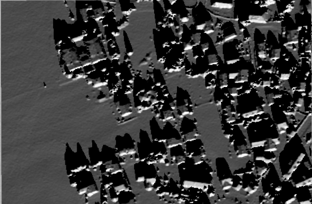
First, In order to use ‘Hillshade’ function to simulate the illumination of a DSM from one specific sun angle. I use ‘ NOAA Solar Calculator‘ to calculate the angle of the sun in a specific time. In this experiment, I set the time 11 A.M on late December, and get my result like this.Hillshade from sun.PNG

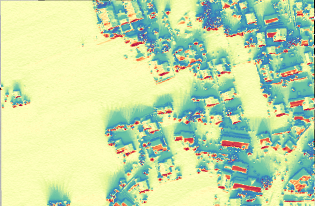
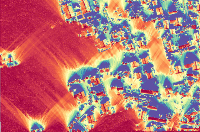
Then, Instead of calculating sun-vs-shade only for one particular date and time, I select to model the duration of sunshine (sunshine hours) which requires following the path of the sun for one day(21st, Dec) and aggregating the hours of solar exposure. This is done with the Area Solar Radiation tool, using the DSM as Input Raster. Besides, I set 0.5h as ‘Time Interval’. My result of this part like this.

  1. Global Radiation Raster

output global radiation raster.PNG

2. Sunshine Duration RasterAreasolarDurationRaster.PNG

From the above experiment, I can get the duration of sunlight exposure at any specific time, however, the generation of solar thermal energy is not only sunlight exposure but rather the angle between the local surface and incident solar radiation – sunrays and radiation hitting the surface at a perpendicular (90°) angle resulting in maximum energy reception. In this sample, We can therefore check for rooftops where solar panels would generate the highest yield, which would be the most favourable locations for placing panels and collectors.

Selected Topics(07/12/2015)

Through Mr Strobl’s presentation, combined with my former experience. I summarized some major trends in GIS.

1.GeoDesign. Maps are a way to abstract places to make it easier to understand.  With GeoDesign, we move beyond simply understanding place, to designing it.  This more active, engaged, and proactive approach to designing with geography is being enabled by an evolving set of new tools in GIS. With the release of ArcGIS 10 came the addition of feature templates, a ‘pen-in-ink’ sketching and data-creation experience that allows plans to be created and analyzed using existing geoprocessing models for suitability analysis.

2.Volunteered geographic information(VGI). VGI is the harnessing of tools to create, assemble, and disseminate geographic data provided voluntarily by individuals (Goodchild, 2007). It is a special case of the larger Web phenomenon known as user-generated content. VGI can also be seen as an extension of critical and participatory approaches to geographic information systems. Big problem for today’s geography is that it is hard for common people to use GIS tools. It is still a kind of principle which live far away from our daily life.

3.Big data. Big data referred to datasets that are too large or too complex or changing too rapidly to provide them with the manual and traditional methods of data processing to evaluate. As the internet grows so fast, huge amount of data needed to be processed. How to use these data and mining the potential information is important for GIS.

Selected Topics(30/11/2015)

A comparison of services supplied
by urban green spaces of two cities

It’s an interesting comparison using GIS techniques to research deeper on human geography. One suggestion from my part, I did some questionnaires like her survey, and I use online quiz to complete this experiment. There are some good reasons for online questioning. 1 Free the investigator. Research on the road for the whole day can really make people exhausted. With online method, we just need to click the mouse. 2 Larger samples. It can be easier to attract more people. We can just send links to our friends and let them recommend to other people. 3 Respect of privacy. People may not welcome your investigation because of time or privacy issues even when you want to make a anonymous survey.

For the major experiment part and also her thinking is good for me. I think Chinese GIS scholars could focus more on human beings.

Selected Topics(23/11/2015)

So surprise that I can have lectures presented by Chinese scholars. The research problem they focused on is really practical and valuable in China. Because our country, especially in Northwest part is lack of water. The fast growth in economy caused some environmental problems and the most obvious one is land desertification. It’s good that we realized this problem in time and changed a lot in recent days. Few questions I have asked after the lecture are like follows:

1.  Is this restoration process sustainable, especially during dry season.

2. Is there are any obvious environmental difference of between man-made water and the original river?

Selected Topics(16/11/2015)

Satellite-based Shelter Detection

I was impressed by some points he mentioned. First, using satellite data is really important for detecting in conflict areas. Second, his method has strong transferability. Through some programming experience, I think transferability is really useful for saving time, and based on his specific problem, transferability is important for emergency use. By the way,  just a small confusion is that, the researcher focused on camps, which is different in shape for different type of camps. However, if we focus on some items much similar in shape, if object-based image analysis still useful? Do we need a similarity measurement before detecting objects?

Selected Topics(19/10/2015)

Crime Risk Perception

Nice topic for me, because I’m interested in crime prediction model. However, through some policy issues, I failed before. To this topic, two points really come into my mind.

First, data acquisition. Unlike traditional Geographic issues, crime data can not been collected manually, on the other hand, it is hard to obtain in most countries. As far as I know, only United states and United Kingdom have some free crime data. I understand the difficulties for government to make it highly secured data. However, I still think if we can find a balance between government and scholars, and at least share some of the data for researching. For instance, government can only share these data to universities or other institutes first. University users can use the data only after verify. Watermarking is a technique which is good for data safety. If we can use it and embed user’s name into this data, it can be easy to find the one once data leakage occurs. This can help users pay more attention on the security of data.


Second, use social media as the source of our data. Nowadays, social media can provide us various of data. If we can use these data, like people’s perception or emotion about which kind of crime, or even location of criminal cases, it will be really precious. I know for some reasons, it is hard for applying this thinking now, however it could be one of the way ahead for criminal analysis or prediction.